GIS theory
A Geographic Information System (GIS) is a system for gathering, processing and presenting data based on geographical references. In Piper, the GIS displays well data on a map based on one of the standard coordinate systems (DLS, NTS, Lat/Long, etc).
Overview of Mapping Systems
This section describes how locations are displayed using the different mapping systems. There are five grid display modes available in Piper:
- Latitude/Longitude
- Dominion Land Survey (DLS)
- National Topographical System (NTS)
- Cartesian
- Universal Transverse Mercator (UTM)
Datum
A datum is a reference from which measurements are made. For Piper's GIS, a geodetic datum is a set of reference points on the earth’s surface against which entities are positioned.
In Canada and the United States, the North American Datum of 1927 (NAD27) and the North American Datum of 1983 (NAD83) are the two official datums used for geodetic systems. Piper currently defaults to NAD83. Latitude/longitude information in NAD83 format will be positioned accurately on the map.
Latitude / Longitude
Latitude is a measure of how far a point is from the Earth's equator. Latitudes may vary from 0 to 90 in both north and south directions. Latitude lines are all parallel. There is a constant distance separating latitude lines of about 110 km (69 miles) per degree. In Piper latitudes in the Northern hemisphere are represented with a positive value and latitudes in the Southern hemisphere are represented with a Negative value.
Longitude is an angular distance that is measured using the prime meridian as a reference. The prime meridian is an imaginary line that connects the North and South poles while passing through Greenwich, England. The ranges for longitudes are 0 - 180 East and West. Longitude lines are not parallel. The distance between two points that are separated by a fixed longitude depends on their latitude. Longitude varies from about 110 km (69 miles) per degree at the equator to a few meters (or feet) per degree at the poles. In Piper longitudes in the Western hemisphere are represented with a negative value and longitudes in the Eastern hemisphere are represented with a positive value.
To further divide degrees of latitude and longitude seconds and minutes are used:
- 1 degree = 1 o = 60 minutes
- 1 minute = 60 seconds
As an example of latitude and longitude, here are the approximate locations of a few cities around the world:
Examples of Latitude and Longitude
| Location | Latitude | Longitude | Notes |
|---|---|---|---|
|
Greenwich, England |
51o, 29 min N |
0 o, 0 min |
This is the reference point for longitude. |
|
Calgary, Canada |
51o, 3 min N |
114o, 3 min W |
This city is located north of the Equator and to the west of Greenwich. |
|
Perth, Australia |
31o, 57 min S |
115o, 52 min E |
This city is located south of the Equator and to the east of Greenwich. |
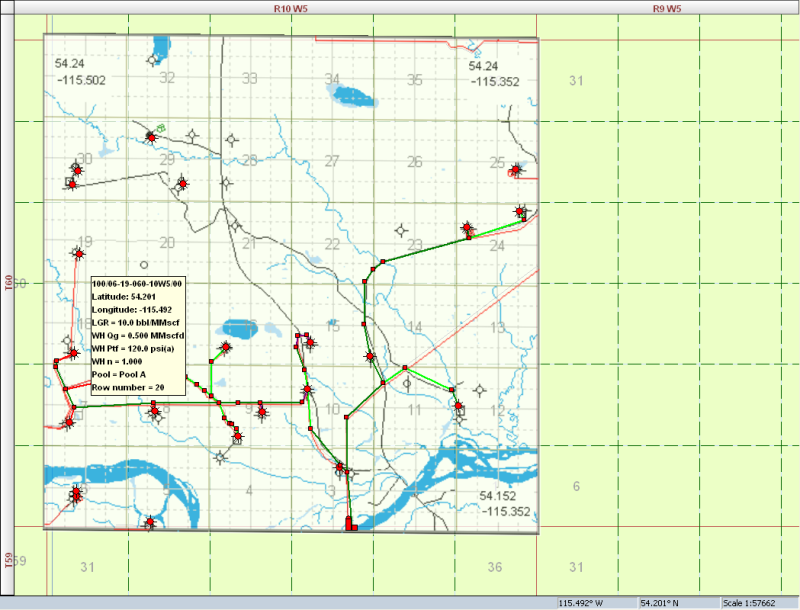
Dominion Land Survey (DLS)
The DLS system is used in the provinces Alberta, Saskatchewan, Manitoba, and British Colombia in Canada.
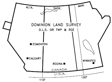
Areas in Canada where the DLS system is used
Example Location: 100/04-11-082-04W6/0
We can read the parts of the UWI as the following:
| Unique Well Identifier Format | Location Exception | Legal Sub division | Section | Township | Range | Meridian | Event Sequence code |
|---|---|---|---|---|---|---|---|
|
1 |
00 |
04 |
11 |
082 |
04 |
W6 |
0 |
Unique Well Identifier format
This number identifies the use of a DLS system.
Location Exception code
This is used when there is more than one hole drilled per legal subdivision. For more details on what can be included in the exception code, see EUB Guide 59.
Meridian
The meridians are 4 degrees of longitude wide that divide the DLS provinces. The West 4 meridian corresponds to 110 degrees west.
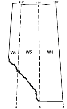
The meridians corresponding to Alberta, Canada
Range
The ranges further divide the meridians. At the southern edge of Alberta, there are 30 ranges per meridian. The number of ranges per meridian decreases as the lattitude increases. Each range is 6 miles (9.7 km) wide.
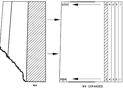
Ranges in Alberta
Townships
The townships divide the provinces up in the north-south direction. There are 126 townships in Alberta. Each township is 6 miles (9.7 km) north-south.

Expanded view of ranges in Alberta
Sections
A square one range wide by one township north-south contains 36 sections. Each section is 1 mile (1.6km) per side.
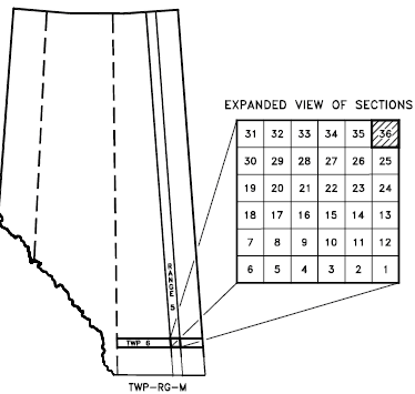
Expanded view of sections
Legal Subdivision
Each section is further divided into 16 legal subdivisions (LSD). An LSD is the smallest division in the DLS system. Each LSD is a square of 1320 ft (402m) per side.

Expanded view of LSD
Event Sequence
Indicates chronological sequence of drilling or completion activities.
National Topographic System (NTS)
The National Topographic Map Numbering System is a system used by Canada to provide general purpose maps of the country.

Example Location : a-10-D-93-P-2
| Quarter units | Units | Blocks | Series Numbers | Map Areas | Map Sheets |
|---|---|---|---|---|---|
|
a |
10 |
I |
93 |
P |
8 |
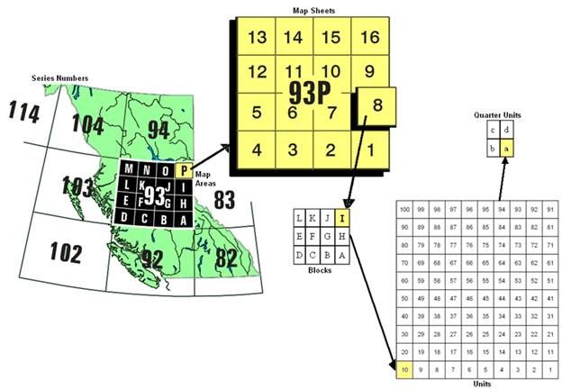
Series Numbers
The series numbers identify rectangular areas that have a width of 8 degrees of longitude (width) and 4 degrees of latitude (north south). Series number 93 is located in the province of British Colombia.
Map Areas
The map areas divide the series numbers into 16 pieces that are labelled A to P. Each map area is 2 degrees of longitude (width) and 1 degrees of latitude (north south).
Map Sheets
Each map area is divided into 16 numbered map sheets.
Blocks
The map sheets are divided into 12 blocks that are labelled from A to L.
Units
The blocks are subdivided into 100 units. The direction of the numbers is always towards the left, unlike the numbering of map sheets.
Quarter Units
Each block is subdivided into quarter units labelled a to d.
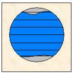
Universal Transverse Mercator (UTM) Grid
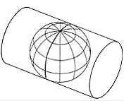
The Universal Transverse Mercator Grid is an attempt to draw the Earth on a cylindrical projection. The word transverse implies that the cylinder is "wrapped" around the Earth in a north-south direction, as shown in the following figure.
The equator is used as the reference point in the north/south direction. The east/west reference is decided upon by the user. Caution should be used in using coordinates that are very far apart as UTM zones are intended to be only 6 degrees longitude in width.
Example location: 317km W, 6532km N
| East/West | North/South |
|---|---|
|
317km west |
6532km north |
East / West
The location is 317 km (198 miles) to the west (W) of longitudinal reference point.
North / South
The location is that the well is 6532 km (4083 miles) to the north (N) of the equator.
Cartesian
Cartesian coordinates describe a location in terms of distance from a defined reference point. The Y axis, which corresponds to longitude increases in the east direction. The Y axis, which corresponds to latitude increases in the north direction.
Example location: - 317km, 6532km
| X axis (East/West) | Y axis (North/South) |
|---|---|
|
317km west |
6532km north |
East / West
The negative sign indicates that the location is to the west of the defined reference point.
North / South
The location is to the north of the reference point. In most cases this reference will be the equator.
References
Well Drilling and Completion Data Filing Requirements, EUB Guide 59, Alberta Energy and Utilities Board, June 2004.
University of Northern British Colombia GIS Lab Website (2009).